
Walking the Mitigation at Rapid Lightning Creek Trail
A Hike Through Albeni Falls Dam History in Northern Idaho

As my husband, Ken, and I prepared to step onto the Rapid Lightning Creek trailhead at the Trout Creek Wildlife Management Area (WMA) just outside Clark Fork, Idaho, I stopped. Before me stood a brown Idaho Fish and Game (IDFG) sign.
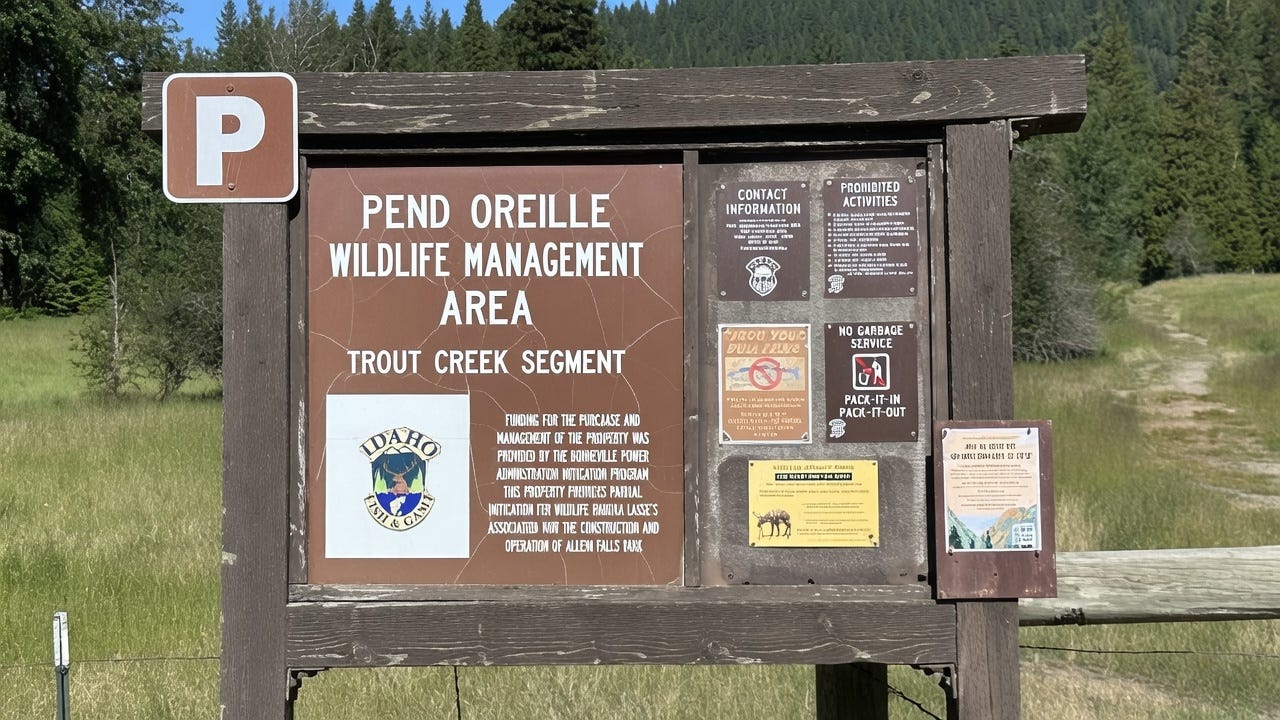
It read:
“Funding for the purchase and management of this property was provided by the Bonneville Power Administration Mitigation Program. This property provides partial mitigation for wildlife habitat losses associated with the construction and operation of Albeni Falls Dam.”
My interest was sparked.
I knew of the dam, which controls the water level of Lake Pend Oreille (located approximately 50 miles northeast of Spokane, Washington, in the Northern Idaho Panhandle), because it had frequently been in the local news. The US Army Corps of Engineers, which owns and operates it, had identified major structural damage. To prevent flooding in the spring, water levels were kept unusually low. That decision upset many who profit from or simply enjoy the lake’s use in the spring and summer.
Now I wondered, what kind of damage had it caused wildlife?
I snapped a photo of the sign, determined to learn more. First, I had a hike to complete.
The Hike:
We followed a wide, winding path through a green pasture, then entered a coniferous forest shaded by tall Cedars and Douglas Fir. We crossed a footbridge over the babbling water of a rock-lined creek and entered sunny terrain bordering the trout-filled Pack River.
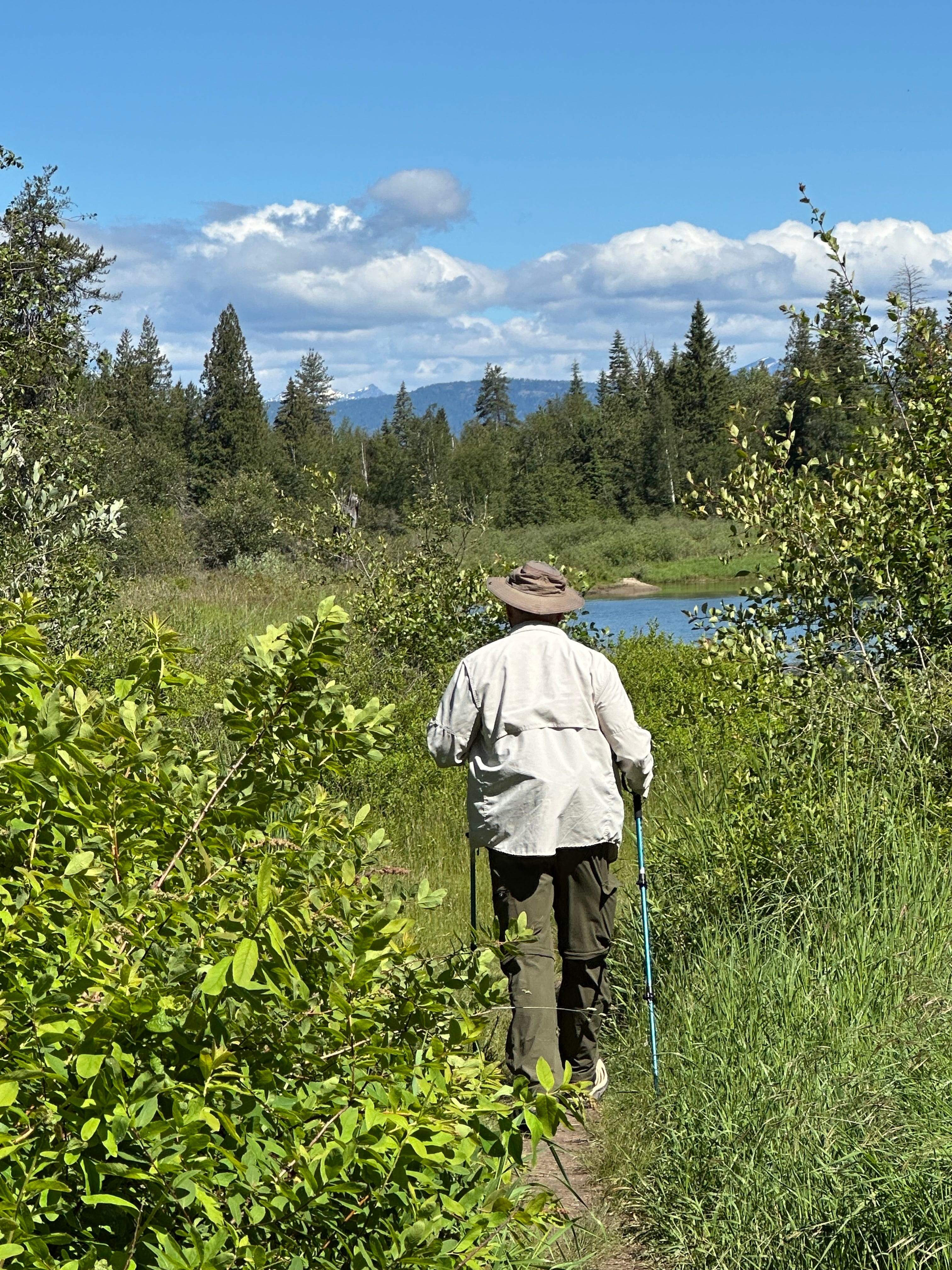
About a mile in, we continued up a short hill and stopped to admire the Selkirk Mountains in the distance, some still snow-capped in mid-June.
We passed few other people on our mid-morning adventure, but we were accompanied by butterflies hovering nearby: black-and-white Swallowtail and dark Mourning Cloak. A chorus of Cedar Waxwings, Orange-crowned Warblers, sweet Vireo, and Black-capped Chickadee followed us.
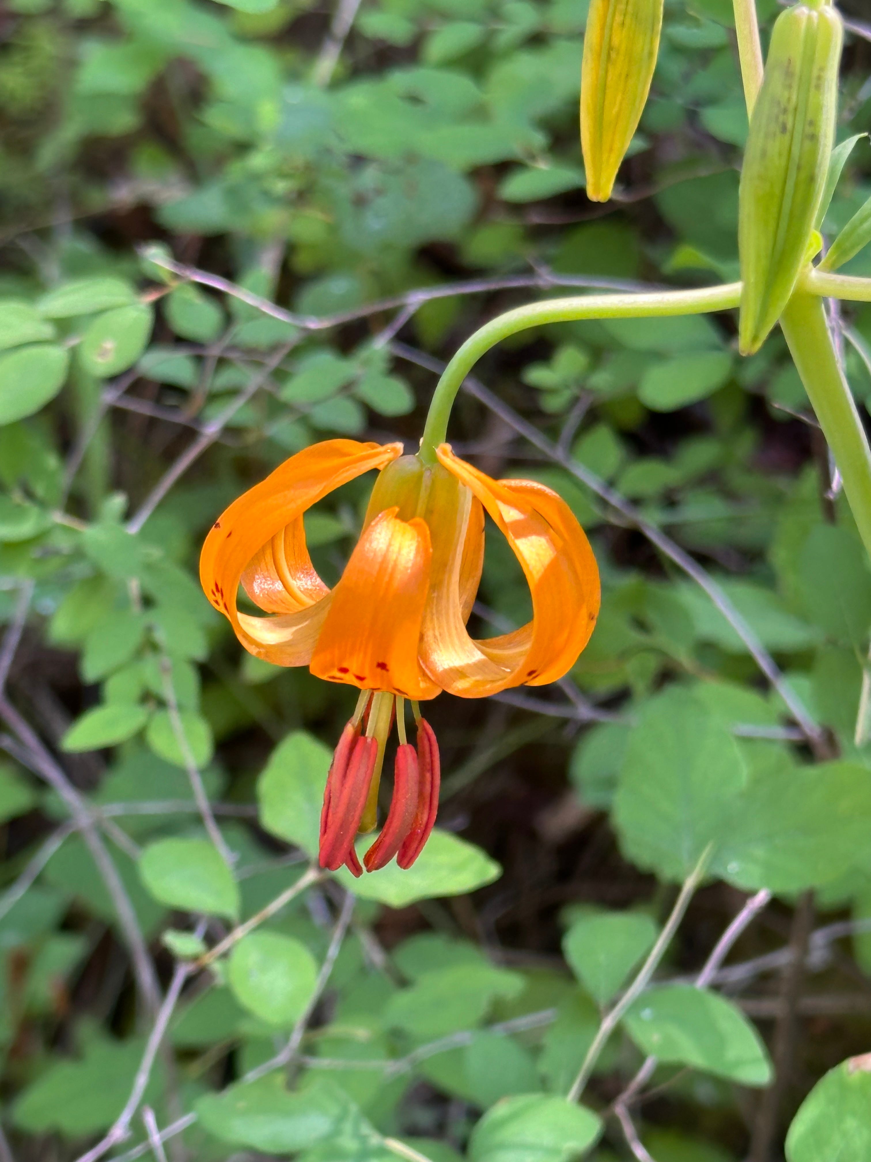
Occasionally, the path before us split. We stopped to check our downloaded AllTrails map before continuing. I snapped photos of the wildflowers around us: yellow goatsbeard, orange hawkweed, purple-blue lupine, and, best of all, the delicately backward-curled Columbia Lily.
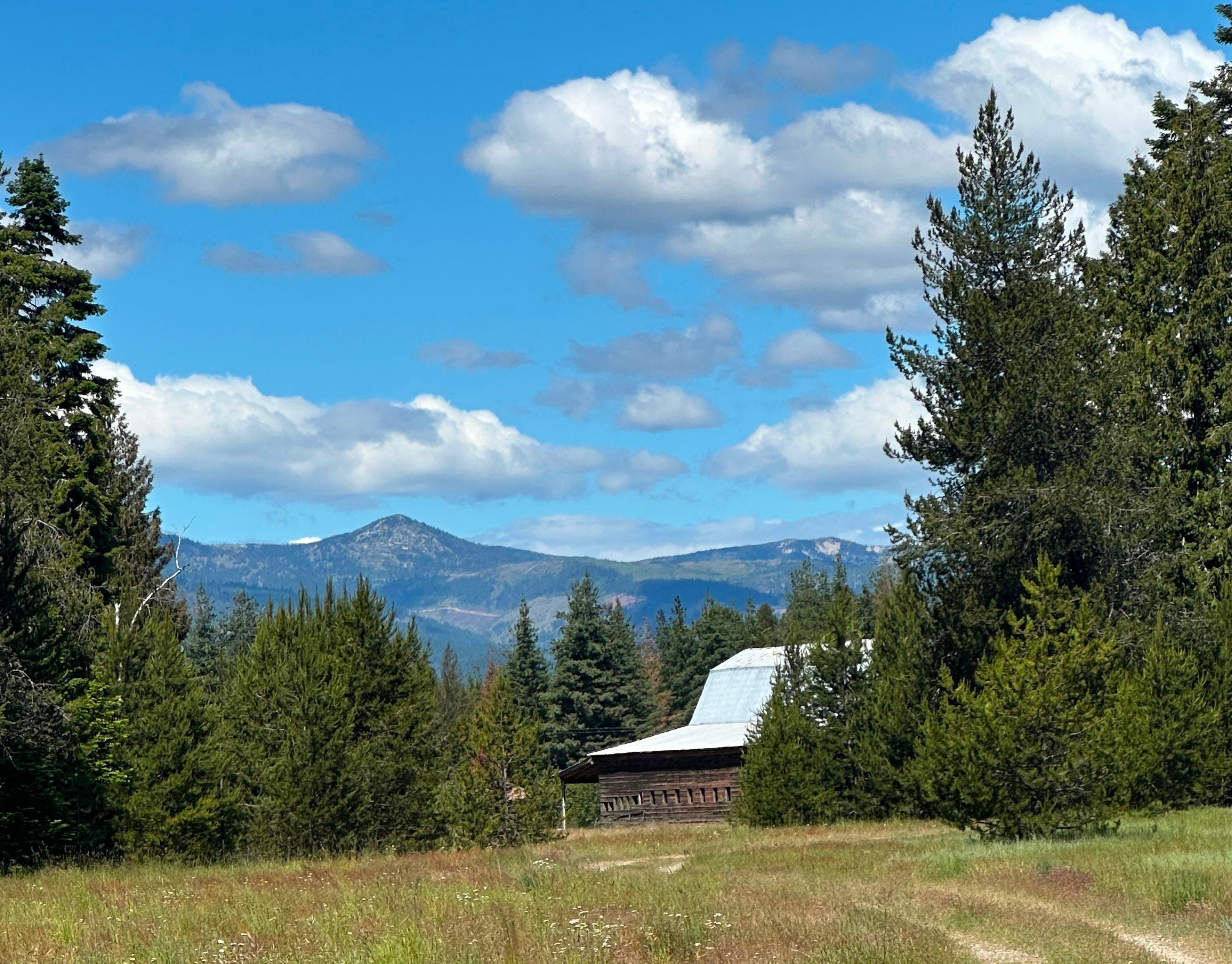
After we’d walked nearly three miles, we came upon a wooden barn in a serene pasture, with mountains in the distance. Moments later, we reached the turnaround point at a second trailhead in Sandpoint, near Rapid Creek Lightning Road, which gives the trail its name.
We stopped for pictures, a water break, and to reapply mosquito spray. I’d learned my lesson after my last adventure and carried it in the pocket of my hiking pants. Then we returned from whence we came, walking a total of 5.6 miles.
I glanced at the sign again as I placed my hiking sticks in my car. That afternoon at home, I opened my computer and continued my trip, this time, through history.
The History:
I learned that the Albeni Falls Dam was constructed in the early 1950s, one of many dams built after a catastrophic flood in the region in late May and early June of 1948. 51 people were killed by the high waters. Property damage exceeded $100 million (equivalent to $1 billion today). Crops on 250,000-plus acres of farmland were destroyed; an additional 20,000-plus acres were ruined by erosion. In the Vanport community in Oregon, 19,000 people were left homeless (Paulsen, 1949).
While the dam benefited many via flood mitigation and affordable energy, it also brought harm.
6,617 acres of wetland habitat were lost, and 8,900 acres of deep-water marsh were flooded, altering the landscape and what could survive and thrive. Area where bald eagles, Canada geese, white-tailed deer, and muskrats bred and fed was gone (IDFG, 1997).
The construction of this dam, among others, also stopped native salmon and steelhead runs that once reached Lake Pend Oreille and the Clark Fork River. The territory of the bull trout and westslope cutthroat was left endangered. Millions of fish dead.
The Bonneville Power Administration (BPA), identified on the IDFG-posted sign, markets and sells energy generated by the dam. It has been making payments to mitigate damage since 1980, when Congress passed the Pacific Northwest Electric Power Planning and Conservation Act, requiring the BPA to “protect, mitigate, and enhance fish and wildlife” (BPA, n.d.).
The BPA reached an additional $24 million settlement in 2018 with the State of Idaho to finish shoreline remediation projects and for future care of Idaho’s mitigated lands (NPCC, 2018).
When walking along the winding Pack River, with its clear water, tall sandy banks, and chirping birds, it’s easy to miss that this isn’t how it should look. The banks are eroding. The water no longer floods each spring as it once did, bringing nutrients to native trees and flowers. The hawkweed I admired shouldn’t be there.
As I think about Rapid Lightning Creek Trail, I’m reminded that the choices we make alter both the world and our lives. I know I’ve made both good and bad ones over the last 50 years. Nonetheless, like Northern Idaho, which is bumpy, scarred, and reimagined, my life remains beautiful.
JUST THE FACTS: Rapid Lightning Creek Trail
Distance: 5.6 miles (total out and back)
Estimated Time: ~2.5 hours
Elevation Gain: 416 feet
Key Highlights: Access to the Pack River and views of the Selkirks.
Difficulty: Moderate. Only a few hills along the wide, well-maintained trail. Great for kids and dogs. Moderate because of the distance.
Call for Comments: Have you hiked Rapid Lightning Creek Trail? Share your stories, tips, and local history in the comments, or submit to Reader’s Hike to have your adventure highlighted.
My Next Hike: Schweitzer Nature Trail: 5.3 miles total out & back: 1,676 ft elevation gain: estimated time: 4 hrs. I hope you’ll read along.
Subscribe for weekly hike guides, practical trail info, and ‘Off the Trail’ personal essays. Let’s build this community together.
References:
Paulsen, C. G., et al. (1949). Floods of May-June 1948 in Columbia River Basin. U.S. Geological Survey Water-Supply Paper 1080. United States Department of the Interior. https://pubs.usgs.gov/wsp/1080/report.pdf (Detailed report on the 1948 Columbia River Basin floods, including death toll, property damage, and impacts in the region.)
Idaho Department of Fish and Game (IDFG). (1997). Project 9206100 - Albeni Falls Wildlife Mitigation Implementation. Bonneville Power Administration Fish and Wildlife Program proposal. Northwest Power and Conservation Council. https://cfw.nwcouncil.org/Content/FWProgram/ReviewCycle/fy1997/projects/9206100.htm (Project details on wildlife habitat losses from Albeni Falls Dam, including acres affected, mitigation goals, and ongoing shoreline issues.)
U.S. Army Corps of Engineers. (n.d.). Albeni Falls Dam. Northwest Division. https://www.nws.usace.army.mil/Missions/Civil-Works/Locks-and-Dams/Albeni-Falls-Dam/ (Official project page with construction history from the 1948 flood response, dam specifications, operations, and current lake conditions.)
Bonneville Power Administration (BPA). (n.d.). Fish & Wildlife Program. https://www.bpa.gov/environmental-initiatives/efw/fish-wildlife-program (Overview of BPA’s mandate under the 1980 Pacific Northwest Electric Power Planning and Conservation Act to mitigate impacts on fish and wildlife from federal hydropower projects.)
Northwest Power and Conservation Council. (2018, September 14). Idaho and BPA Sign $24 Million Wildlife Settlement For Albeni Falls Dam. https://www.nwcouncil.org/news/2018/09/14/idaho-and-bpa-sign-24-million-wildlife-settlement-albeni-falls-dam-0/ (News announcement on the 2018 settlement for shoreline remediation and future management of mitigated lands.)