

What makes Northern Idaho special? Yes, it’s the vast mountain ranges and deep glacial lakes, a landscape so glorious it rivals the teal mountains of Bora-Bora and the blue waters of Hawaii. More than that, it’s the people who value this little-recognized treasure.
I was reminded of this at the trailhead for Mickinnick, a 7-mile out-and-back hike in Bonner County where a sign summarizes its history. In 1997, Nicky Pleass donated 160 acres to the U.S. Forest Service in memory of her late husband, Mick. Both of them had envisioned a scenic trail directly above Sandpoint. They wanted the land preserved for future generations.
It is impossible to come to this area and not want to protect it. Nicky was originally from England. I came from the East Coast, and still catch myself wishing no one else would move here every time I see another tree felled for a new house.
That desire to safeguard this area has been demonstrated on other trails I’ve taken, such as at Pine Street Woods, where the Kaniksu Land Trust, with help from community donations, conserved 180 acres of land for a community forest. These are precious gifts. They matter.
Even on a hotter-than-forecast day, 84 degrees instead of the mid-70s, Ken and I were not alone as we climbed the steep switchbacks up the southeastern flank of Bald Mountain. Smiling couples and solitary walkers passed us, some with panting dogs.
Mickinnick earns its popularity: easy parking, a well-maintained path, and the chance of spotting moose among the thimbleberry and huckleberry. Benches appear before the first mile is done and at several points along the way, so there’s no need to hike all the way to the summit for the amazing views.
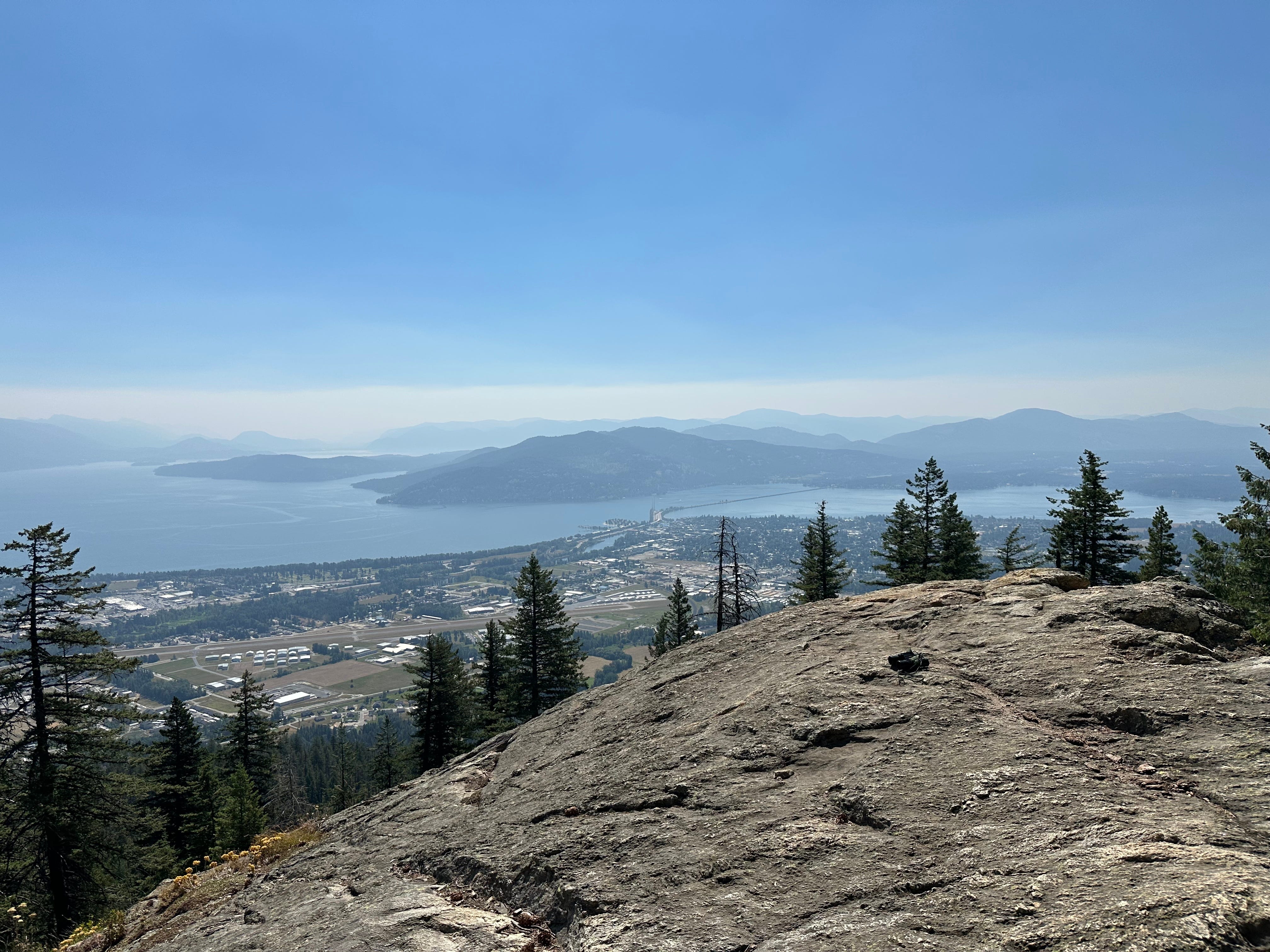
Smoke from Canadian wildfires partially obscured the Cabinet Mountains in the distance, but the city of Sandpoint below looked like a perfect miniature. The Long Bridge stretched across Lake Pend Oreille like Mr. Rogers’ trolley heading into the Neighborhood of Make-Believe.
Don’t, however, let the enchantment distract too much. This is a steep, tiring trail. Ken tripped over a tree root protruding from the dirt on the way down. Took a scary tumble, stopping just short of a fallen log on the hillside. Luckily, he walked away with just a scraped-up arm. Another thing to be grateful for.

I’m loving this adventure of hiking 50 trails, even with occasional stumbles. It’s a chance not only to appreciate the land but also the people who protect it and make it accessible. Maybe I can become one of those people, too.
JUST THE FACTS: Mickinnick Trail
Distance: 7 miles (total out and back)
Estimated Time: ~ 5 hours
Elevation Gain: 2,152 feet
Key Highlights: Views of Sandpoint and Lake Pend Oreille, early benches, wildlife potential (moose), meaningful local conservation history
Difficulty: Hard
Call for Comments: Have you hiked Mickinnick Trail? Share your stories, tips, and local history in the comments, or submit to Reader’s Hike to have your adventure highlighted.
Subscribe for weekly hike guides, practical trail info, and ‘Off the Trail’ personal essays. Let’s build this community together.